
Google-owned traffic and navigation app, Waze announces the launch of the Waze Global Event Partner Program to help stadiums, marathons and other event organizers worldwide outsmart event-related traffic and better communicate road information with its attendees and broader community. The program is free and available globally to these organizers of all sizes.
With more than 50 million monthly active Wazers globally and more than 4,000 events successfully supported to date, Waze said that it will provide partners with custom access to its traffic management technologies and communications channels in exchange for partner’s advanced and real-time road closure and traffic information.
The Waze Global Event Partner Program provides an easy, real-time technology solution for stadiums, marathons and event organizers to share road and traffic information directly with Waze through:
● The Waze Closure Tool: Previously available only to Waze Connected Citizens municipal partners, event partners can now add road closures directly to the Waze map.
○ Partners also can work directly with Waze, in advance or real-time, to add turn restrictions, lane reversals, parking lot locations and more to the map.
● Waze Live Map: Allows partners to easily monitor traffic in real-time via a custom Live Map on desktop and mobile. Partners can also embed the iFrame Live Map on their own websites.
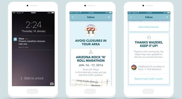
● Waze Communication Channels: Beyond tools, Waze provides unique channels to reach drivers including in-app branded messages informing locals of pertinent event and road closure information, a custom landing page on www.waze.com/events with a map and list detailing road closures.
The Waze Global Event Partner Program launches with more than 20 partners including E15, a subsidiary of Levy Restaurants focused on enhancing event operation performance. The Rock ‘n’ Roll Marathon Series is also an early partner, providing Waze with official road closure information for its 30 races around the globe.
The announcement is the latest expansion of Waze enterprise services, providing free data-driven solutions to varied partners, from transport companies to municipal organizations, to offer more efficient routes that yield safer roads.
Orit Yehezkel, Head of Localization at Waze
Through the Waze Global Event Partner Program, we are working directly with partners to alleviate this pain point for attendees, extending a quality event experience to include the roads and parking lots.
Kara Kong, VP of Community Relations for the Rock ‘n’ Roll Marathon Series
Having the ability to reach locals through Waze not only ensures our participants know how to navigate road closures and arrive to the start line on-time, but that anybody driving around on race day has the best and most accurate road closure and alternative route information.